
Advanced Python Programming for GIS
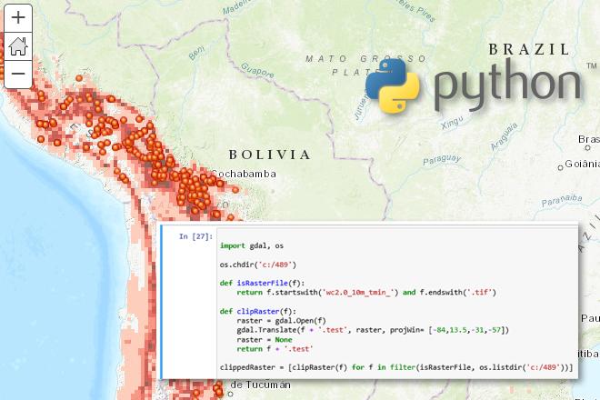
Credit: Jan Oliver Wallgrun, © Penn State University, (CC BY-NC-SA 4.0)
Resource Description
In GEOG 489, you will learn advanced applications of Python for developing and customizing GIS software, designing user interfaces, solving complex geoprocessing tasks, and leveraging open source. The course consists of readings, walkthroughs, projects, quizzes, and discussions about advanced GIS programming concepts and techniques, and a final term project. It complements the material covered in GEOG 485: GIS Programming and Customization. Software covered in the course includes: Esri ArcGIS Pro/arcpy, Jupyter Notebook, Esri ArcGIS API for Python, QGIS, GDAL/OGR. Students will also make use of the Git version control software for code management, and learn techniques for distributing Python applications to end users. Learn moreCartography and Visualization
Resource Description
Maps are powerful visual tools, both for communicating ideas and for facilitating data exploration. In GEOG 486: Cartography and Visualization, you will learn design principles and techniques for creating maps with contemporary mapping tools, including ArcGIS Pro. In this lab-focused course, you’ll apply cartographic theory to practical problems, with a focus on design decisions such as selecting visual variables, classifying and generalizing data, applying principles of color and contrast, and choosing projections for maps. You will also be introduced to future-focused application topics such as augmented and virtual reality, mapping with multivariate glyphs, the visual depiction of uncertainty, interactive geovisualizations and (geo)visual analytics, and decision-making with maps and mapping products. Successful completion of this course will signify mastery in map production for communication and research; you will be practiced in making, analyzing, critiquing, and sharing high-quality maps. Learn moreMaking Maps that Matter with GIS
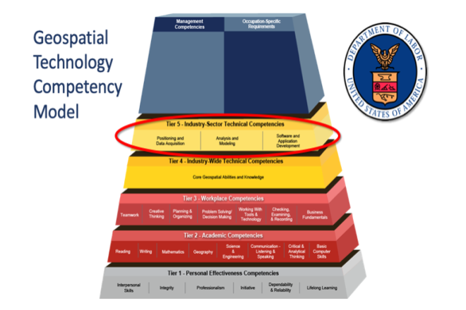
Credit: US Department of Labor Employment & Training Administration - Used with Permission
Resource Description
This open courseware consists of eight videos from the gateway course to Penn State's Certificate and Masters degree programs in GIS. Following an introduction entitled “Why GIS Matters," six case studies correspond to the three sectors of the U.S. Department of Labor’s Geospatial Technology Industry: 1. Positioning and Data Acquisition (“GIS and the Eradication of Polio in Nigeria” and "A Global Geodetic Reference Frame for Sustainable Development”) 2. Analysis and Modeling (“Everyday Spatial Analysis” and “A National Water Model for Flood Prediction and Response”) 3. Software and App Development (“Rediscovering GIS” and “Building a Web GIS Business) The concluding video "Will GIS Matter in the Internet of Things?” considers the future of GIS technology and prospects for GIS people. Making Maps that Matter with GIS Video Playlist Learn moreMapping our Changing World

Credit: Space Station Flyover of Super Typhoon Noru by NASA is Public Domain
Resource Description
Whether you realize it or not, when you carry a smart phone, use a navigation system in your car, or look up the nearest coffee shop on your computer, you are using geographic information. Geographic data and technologies are embedded in almost all aspects of our lives. GEOG 160, Mapping Our Changing World, explores what geographic information and data are, what makes them unique, how they are created, and how we use them. You'll explore how geographic technologies like geographic information systems (GIS), remote sensing from satellites, and global positioning systems (GPS) work together to provide us with information we rely on. You'll also become an informed consumer of the geographic content in your life. Learn moreMaps and the Geospatial Revolution
Credit: A. Robinson © Penn State University is licensed under CC BY-NC-SA 4.0