
Geospatial Intelligence and the Geospatial Revolution
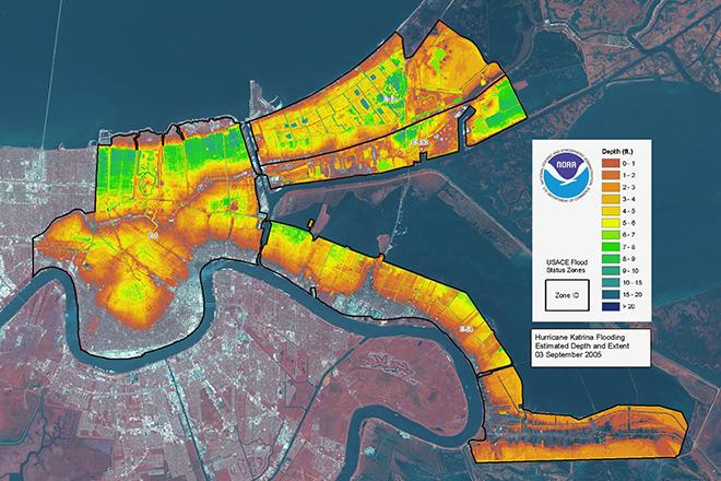
Credit: LIDAR map of New Orleans flooding caused by Hurricane Katrina, 3 September 2005 from ESA/NOAA is licensed under CC BY-SA 3.0 IGO
Resource Description
Geographic Intelligence (GEOINT) is more than people working with computers in a secure intelligence facility. Join us for this exciting journey to learn about GEOINT's application in business, law enforcement, and defense. Advances in satellites, GPS, unmanned aerial systems, wireless communications, handheld computing, and the ability to automate laborious map analysis processes has transformed what used to be called geographic intelligence, or GEOINT, and the nature of the insights provided to managers and leaders. We have gone from mountains of hardcopy maps to amazing automated systems that provide previously unavailable understanding. GEOINT combines geographic information science and technologies with an analytic tradecraft. You will experience the value of GEOINT. We welcome you to the Revolution. Learn moreGeospatial Technology Project Management

Credit: Time-lapse Photography of Vehicle Lights by Kaique Rocha is free to use
Resource Description
In GEOG 871, we'll take a critical look at geospatial project management. Project management is a broad discipline that encompasses technical methods such as system design and analysis and also interpersonal factors that affect professional relationships. Project management is also a discipline that has matured outside of, but can be incorporated into, geospatial technology. By the end of this course, you'll have devised a project plan from a scenario built upon a real-life project involving the city of Metropolis geodatabase. We'll work through each of the components in an organized and logical manner and will incorporate constructive peer review to help everyone achieve the best product possible. Learn moreGIS Analysis and Design

Credit: Architectural, design, architecture buildings 425053 by Juhasz Imre is licenced under CC0
Resource Description
Geography 468 provides the geospatial information system professional an overview of systems analysis and design with emphasis on the concepts behind the process, including: business use case modeling, business object modeling, requirements definition, analysis and preliminary design, and, finally, detailed design. The concepts of the geospatial software and database development process are introduced and the current modeling techniques are addressed within the geospatial systems development paradigm. In a series of related activities, students learn about the methods, tools, and concepts of the systems development process to document a portion of a geospatial system with Unified Modeling Language (UML), the standard graphical notation for modeling application needs. Learn moreIndependent Study in Geospatial Intelligence

Credit: Photo by Christopher Gower is free for use
Resource Description
Independent Study is an opportunity for students to work with individual direction from a faculty member on a topic of mutual interest in geospatial intelligence. Students must have strong professional experience or have taken courses in the subject matter leading up to the chosen topic. Independent Study is reserved for advanced specialties or for intermediate study in areas in which the department does not normally offer course work. Faculty members are under no obligation to accept Independent Study students, but do so as their teaching load permits. This option allows students to complete some of their credit requirements by studying on their own. Learn moreMaking Maps that Matter with GIS
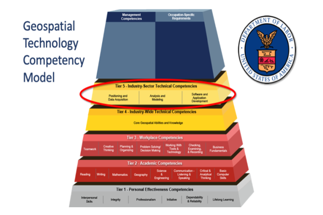
Credit: US Department of Labor Employment & Training Administration - Used with Permission
Resource Description
This open courseware consists of eight videos from the gateway course to Penn State's Certificate and Masters degree programs in GIS. Following an introduction entitled “Why GIS Matters," six case studies correspond to the three sectors of the U.S. Department of Labor’s Geospatial Technology Industry: 1. Positioning and Data Acquisition (“GIS and the Eradication of Polio in Nigeria” and "A Global Geodetic Reference Frame for Sustainable Development”) 2. Analysis and Modeling (“Everyday Spatial Analysis” and “A National Water Model for Flood Prediction and Response”) 3. Software and App Development (“Rediscovering GIS” and “Building a Web GIS Business) The concluding video "Will GIS Matter in the Internet of Things?” considers the future of GIS technology and prospects for GIS people. Making Maps that Matter with GIS Video Playlist Learn moreMaps and the Geospatial Revolution
Credit: A. Robinson © Penn State University is licensed under CC BY-NC-SA 4.0
Resource Description
The past decade has seen an explosion of new mechanisms for understanding and using location information in widely-accessible technologies. This Geospatial Revolution has resulted in the development of consumer GPS tools, interactive web maps, and location-aware mobile devices. This course brings together core concepts in cartography, geographic information systems, and spatial thinking with real-world examples to provide the fundamentals necessary to engage with Geographic Information Science. We explore what makes spatial information special, how spatial data is created, how spatial analysis is conducted, and how to design maps so that they're effective at telling the stories we wish to share. To gain experience using this knowledge, we work with the latest mapping and analysis software to explore geographic problems. Learn moreSpatial Data Science for Emergency Management

Credit: Helicopter Help First Aide by ThePixelman is licensed under CC0
Resource Description
Geospatial perspectives and technologies play a major role in planning for and responding to emergencies. Geospatial tools - from aerial mapping techniques to data acquisition, are changing rapidly as is emergency management as the frequency and magnitude of crises and disasters are increasing. This course provides an understanding of how geospatial perspectives and technologies support all stages of emergency management activities, from small scale emergency management efforts to large scale disaster/humanitarian efforts. This includes learning about commonly used and emerging geospatial tools. It also includes an exploration of advancements in data collection, processing and analysis capabilities, such as unmanned aerial systems, geospatial artificial intelligence, volunteered geographic information, social media, and many more. Learn moreUnmanned Aerial Systems

Credit: Photo by JESHOOTS.COM is licensed under CC0
Resource Description
Unmanned Aerial Systems, or drones, are developing aggressively, and many government and non-government agencies are considering acquiring such systems. This course will focus on the geo-spatial utilization of a UAS. It will cultivate students' knowledge of the capabilities and limitations of the UAS and data post-processing systems. It introduces fundamental concepts surrounding operating a UAS such as strategies for selecting the right UAS, assessing its performance, managing resulting products (i.e. imagery), selecting the appropriate commercially available processing software, assessing product accuracy, figuring ways and means of producing metric products from UAS, and understanding rules and regulations governing operating a UAS in the United States. Learn moreWeb Application Development for the Geospatial Professional

Credit: Ipad, Map, Tablet, Internet, Screen by FirmBee is licensed under CC0