
Advanced Python Programming for GIS
Credit: Jan Oliver Wallgrun, © Penn State University, (CC BY-NC-SA 4.0)
Resource Description
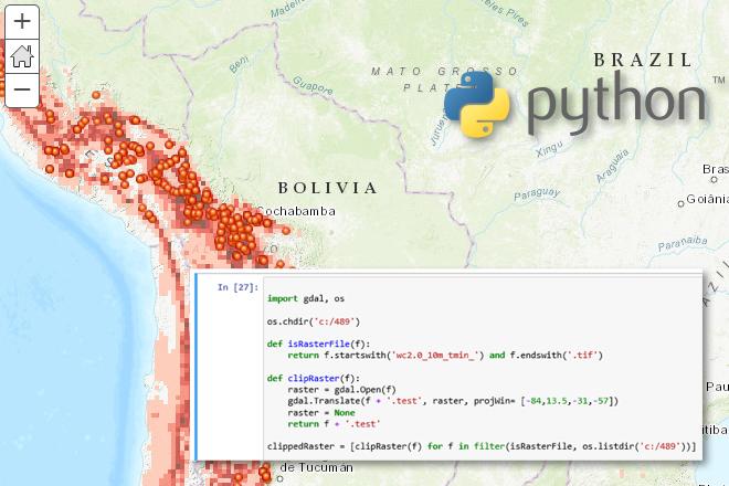
In GEOG 489, you will learn advanced applications of Python for developing and customizing GIS software, designing user interfaces, solving complex geoprocessing tasks, and leveraging open source. The course consists of readings, walkthroughs, projects, quizzes, and discussions about advanced GIS programming concepts and techniques, and a final term project. It complements the material covered in GEOG 485: GIS Programming and Customization. Software covered in the course includes: Esri ArcGIS Pro/arcpy, Jupyter Notebook, Esri ArcGIS API for Python, QGIS, GDAL/OGR. Students will also make use of the Git version control software for code management, and learn techniques for distributing Python applications to end users. Learn moreOpen Web Mapping

Credit: The Activities of Africa by Mariusz Prusaczyk is licensed under CC0
Resource Description
Everyone can make a web map now, but what are the best tools to do so? Maybe you have already created web maps with ArcGIS or Google Maps but never taken time to have a closer look at open source software alternatives such as QGIS, GeoServer and Leaflet? Or, are you new to web mapping and looking for the best way to create a web application for spatial data from your job or hobby? If so, GEOG 585, Open Web Mapping, is the right course for you. Learn about FOSS vs. proprietary GIS software, open data and standards for web mapping, and how to create beautiful and interactive web maps with Javascript and Leaflet. Learn moreSpatial Database Management
Credit: © Penn State University is licensed under CC BY-NC-SA 4.0