
Spatial Database Management
Credit: © Penn State University is licensed under CC BY-NC-SA 4.0
Resource Description
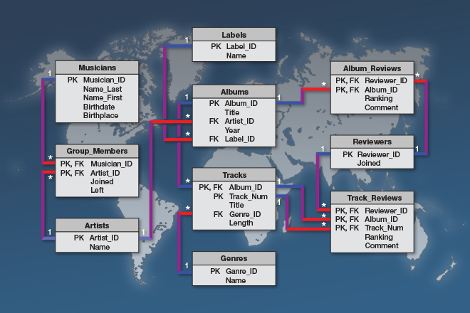
A spatial database is the backbone of a successful organization or website that depends upon maintaining and using data pertinent to locations on Earth. In GEOG 868, Spatial Database Management, capabilities specific to Relational Database Management Systems (RDBMS) and Geographic Information Systems (GIS) are combined to teach students to create, maintain, and query spatial databases in both desktop and enterprise environments. Learn the basics of Standard Query Language (SQL) and database design/normalization, the specifics of managing spatial data in an open-source technologies context (Postgres/PostGIS) and in the context of the Esri geodatabase. Along the way, you will become familiar with spatial functions and versioning, the latter in a server environment hosted by Amazon Web Services. Learn moreUnmanned Aerial Systems

Credit: Photo by JESHOOTS.COM is licensed under CC0
Resource Description
Unmanned Aerial Systems, or drones, are developing aggressively, and many government and non-government agencies are considering acquiring such systems. This course will focus on the geo-spatial utilization of a UAS. It will cultivate students' knowledge of the capabilities and limitations of the UAS and data post-processing systems. It introduces fundamental concepts surrounding operating a UAS such as strategies for selecting the right UAS, assessing its performance, managing resulting products (i.e. imagery), selecting the appropriate commercially available processing software, assessing product accuracy, figuring ways and means of producing metric products from UAS, and understanding rules and regulations governing operating a UAS in the United States. Learn moreWeb Application Development for the Geospatial Professional

Credit: Ipad, Map, Tablet, Internet, Screen by FirmBee is licensed under CC0